Documentation & data
Aerial property and land documentation
A dated visual record of a property and everything on it - buildings, grounds, roads, fence lines, drainage and water - captured once, or on a schedule so change shows up before it becomes a problem.
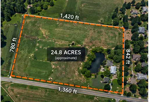 Example
In short
AerialIQ documents commercial properties, land and infrastructure from the air - roofs, facades, parking, grounds, roads, fence lines, drainage and water areas - as a dated visual record, once or on a recurring schedule.
Capture and delivery
What AerialIQ captures, and what you receive
Captured on site
- Overview imagery of the whole property and its surroundings
- Roofs, facades and building exteriors
- Parking areas, drives and paved surfaces
- Grounds, landscaping, drainage paths and detention areas
- Roads, fence lines, gates and structures across larger land
- Water areas, banks and signs of erosion
What you receive
- Labelled image set
- Organised by area of the property, so the same place is easy to find on the next visit.
- Property overview
- Wide images that place every detail on the site.
- Orthomosaic map (optional)
- One top-down image of the whole property, for records and planning.
- Video (optional)
- A continuous pass along roads, fence lines or perimeters.
ExampleWho it is for
Common project situations
Typically commercial property owners and managers, land and ranch owners, hoas and campus facilities, municipalities and public works and brokers and developers.
Commercial property records
Roofs, facades, parking and grounds documented on a dated schedule across a portfolio.
Ranch and rural land
Roads, fence lines, water and structures across acreage that takes hours to drive.
Before and after work
The condition of a property before a project starts, and again when it is done.
After weather
A dated record of grounds, drainage and structures after a storm, for your own files and your insurer.
A record, not a verdict
What property documentation is for
A dated visual record of what a property looked like, captured the same way each time. What the record means - for a repair, a claim, a boundary or a sale - is decided by the right professional.
AerialIQ provides
- Dated imagery of buildings, grounds, roads and water
- Coverage organised by area, so it can be compared later
- Orthomosaic maps of the whole property
- The same areas re-captured on a schedule
AerialIQ does not provide
- Boundary or property-line determinations
- Structural, engineering or environmental assessments
- Insurance adjusting or damage estimates
- Appraisals or valuations
Pricing guidance
How much does aerial property documentation cost?
Pricing
Quoted per project
Starting figures are guidance, not a quote. The final price is confirmed in writing once the scope, location and deliverables are known.
What moves the final quote
- Project scope and the size of the site
- Location and travel from northern Colorado
- Complexity - access, airspace, obstructions, timing windows
- The deliverables required, and how much editing they involve
- Flight requirements such as number of viewpoints or passes
- Recurring work, priced per visit below the one-off rate, with a lower rate again for prepaid terms
Questions
Frequently asked questions
What does property documentation cover?
Whatever needs a record: buildings and roofs, parking and paved areas, grounds and drainage, roads, fence lines, structures and water. The scope is agreed first, and each area is captured and labelled so it can be found again.
Can you document a large ranch or rural property?
Yes. Large properties are planned in sections, with an orthomosaic map for the whole area and detail imagery where it matters - roads, water crossings, fence lines and structures.
Can this be done on a schedule?
Yes. Most property documentation is more useful as a series - monthly, quarterly or seasonal - so change is visible against the last visit. See recurring monitoring for how schedules work.
Will the imagery show my property lines?
Outlines can be drawn from information you supply, as an illustration only. They are not survey lines and must not be relied on for boundaries.
How much does aerial property documentation cost?
Each project is quoted individually. Property size, the number of areas and structures, maps or video, and travel affect the final figure, which is confirmed in writing in the quote.
Can AerialIQ travel to my site?
Yes. Projects throughout Colorado, from a base in northern Colorado. Travel is estimated from the project location and itemised in the quote, so the price reflects where the site actually is.
Next step
Ready to talk about a project?
Send the location, what you need captured and roughly when. That is enough to come back with a scope and a price.