Documentation & data
Aerial construction progress photography and site documentation
A visual record of your project from groundbreaking to completion, captured on a schedule you set once and flown from the same saved positions every visit.
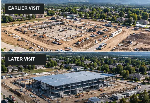 Example
In short
AerialIQ provides recurring construction progress photography on weekly, biweekly, monthly or milestone schedules, captured from consistent viewpoints so images compare directly over the life of a project.
Capture and delivery
What AerialIQ captures, and what you receive
Captured on site
- Progress stills from saved viewpoints, repeated at the same altitude and heading each visit
- Whole-site overview images for orientation and stakeholder updates
- Milestone captures - foundations, framing, enclosure, completion
- Staging, laydown and logistics areas as the site changes
- Orthomosaic maps where a flat, map-like overview is useful
- Before and after pairs for finished work and marketing
What you receive
- Full-resolution stills
- Organised by visit and by viewpoint, so the same angle can be found across every date.
- Site overview set
- Wide images showing the whole site and its surroundings on the day of the visit.
- Progress video (optional)
- A short edited pass, or source clips for your own team.
- Orthomosaic map (optional)
- A stitched top-down view of the whole site for context and communication. Reference only - not a survey.
- A dated download link
- Each visit delivered as its own labelled set rather than one growing folder.
ExampleWho it is for
Common project situations
Typically general contractors, home builders, commercial developers, civil contractors, excavation companies and property developers.
Owner and lender updates
A consistent monthly set that shows progress at a glance, without anyone driving to site.
A record before it is buried
Utilities, foundations and underground work photographed while they are still visible.
Milestone sign-off
Captures timed to specific stages instead of the calendar, when the milestones matter more than the dates.
Marketing the finished job
A before-and-after series from the same positions, for your portfolio and your next bid.
Documentation method
Anyone can fly a good shot. The method is what makes it a record.
Progress photography is only worth anything if two frames taken months apart line up. That means the same position, the same altitude, the same heading, every single visit - recorded once and flown the same way every time after.
Drag, or use the arrow keys, to compare
What a viewpoint stores
Each viewpoint on a project is a saved position the pilot flies to on every visit. It is a specification, not a suggestion, which is what keeps a six-month series comparable.
- Altitude
- 220 ft AGL
- Heading
- 145°
- Gimbal
- -28°
- Interval
- 14 days
Example specification, not a flight record
The same position, across the life of a project
Month 1
Site prep
Month 3
Foundation and framing
Month 6
Envelope closed
Complete
Final documentation
One visit or a schedule
One-time capture or recurring documentation
A single visit records one moment. A schedule builds a history. Most construction clients need the second, but plenty of jobs only need the first.
| Attribute | One-time capture | Recurring documentation |
|---|---|---|
| Best for | A single milestone, a finished job, or one site overview | Projects that need a record from start to finish |
| Viewpoints | Chosen for the day | Saved once and flown identically on every visit |
| Scheduling | Booked individually | Weekly, every two weeks, monthly or by milestone - set once |
| Delivery | One labelled image set | One labelled set per visit, each matching the last |
| Starting price | From $325 per visit | From $250 per visit |
Best for
- One-time capture
- A single milestone, a finished job, or one site overview
- Recurring documentation
- Projects that need a record from start to finish
Viewpoints
- One-time capture
- Chosen for the day
- Recurring documentation
- Saved once and flown identically on every visit
Scheduling
- One-time capture
- Booked individually
- Recurring documentation
- Weekly, every two weeks, monthly or by milestone - set once
Delivery
- One-time capture
- One labelled image set
- Recurring documentation
- One labelled set per visit, each matching the last
Starting price
- One-time capture
- From $325 per visit
- Recurring documentation
- From $250 per visit
Pricing guidance
How much does construction progress photography cost?
Starting guidance
- From
- $325/ visit
- Recurring, per visit
- $250
Starting figures are guidance, not a quote. The final price is confirmed in writing once the scope, location and deliverables are known.
What moves the final quote
- Project scope and the size of the site
- Location and travel from northern Colorado
- Complexity - access, airspace, obstructions, timing windows
- The deliverables required, and how much editing they involve
- Flight requirements such as number of viewpoints or passes
- Recurring work, priced per visit below the one-off rate, with a lower rate again for prepaid terms
Questions
Frequently asked questions
What does construction drone documentation include?
Each visit captures progress stills from a set of saved viewpoints, a wide overview of the site and, where useful, a short video pass. Orthomosaic maps can be added. Every set is delivered labelled by date and viewpoint so it lines up with the previous visits.
How often should a construction site be flown?
Most projects run weekly, every two weeks or monthly. Fast phases such as site work and framing often justify weekly visits; long interior phases rarely do. A schedule can also follow milestones rather than dates. It is set at the start and can change as the project does.
Can the same angles be repeated every visit?
Yes, and that is the point of the method. Each viewpoint is recorded once with its position, altitude and heading, then flown the same way on every visit, so two images months apart show the same framing.
Is this a survey or a way to measure progress?
No. The imagery is a visual record of site conditions on the day. It is not a land survey, it is not survey-grade for measurement, and it is not an engineering or construction assessment. Quantities, percentages complete and compliance stay with your surveyor, engineer or project team.
What if the site is near an airport?
Sites in controlled airspace need FAA authorization before a flight. That is arranged ahead of the visit. It is usually routine, but it can affect which days are available, which is why it is checked before scheduling.
How much does construction progress photography cost?
Prices start from $325 per visit and recurring visits from $250 each. Site size, the number of viewpoints, travel and optional deliverables such as video or orthomosaic maps affect the final figure, which is confirmed in writing in the quote.
Can AerialIQ travel to my site?
Yes. Projects throughout Colorado, from a base in northern Colorado. Travel is estimated from the project location and itemised in the quote, so the price reflects where the site actually is.
Next step
Ready to talk about a project?
Send the location, what you need captured and roughly when. That is enough to come back with a scope and a price.