Documentation & data
Drone inspection imagery for roofs and building exteriors
Detailed aerial photographs of roofs, elevations and hard-to-reach areas, captured without anyone climbing. AerialIQ supplies the imagery; your qualified professional interprets it.
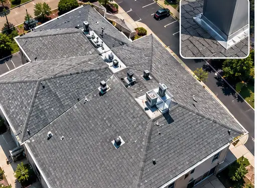 Example
In short
AerialIQ captures detailed aerial imagery of roofs and building exteriors for documentation purposes. AerialIQ provides visual documentation and imagery, not licensed engineering inspections, professional surveys or insurance adjusting.
Capture and delivery
What AerialIQ captures, and what you receive
Captured on site
- An overview of the whole roof and building from above
- Every slope and elevation, photographed in a planned sequence
- Close detail passes on flashing, penetrations, edges and equipment
- High-resolution stills that hold up when zoomed to full size
- Video passes where a continuous view helps orientation
- Before and after sets around repair or replacement work
What you receive
- Full-resolution stills
- The original high-resolution frames, not compressed exports.
- A labelled image set
- Organised by slope, elevation or area so a reviewer can find what they need. A set of photographs, not a condition report.
- Overview images
- Wide frames that show where each detail image sits on the building.
- Video (optional)
- A walkthrough pass of the roof or exterior.
ExampleWho it is for
Common project situations
Typically roofers, property managers, solar companies, building owners and contractors.
Before a roofer quotes
Imagery a contractor can review before or instead of a first ladder visit.
After a storm
A dated visual record of the roof and exterior for your own files, to share with your insurer or adjuster.
Property records
Periodic documentation of roofs and exteriors across a portfolio of buildings.
Solar arrays
Visual imagery of panels, mounting and surrounding roof areas. Standard photography only - not thermal.
Where the imagery stops
What AerialIQ provides, and what it does not
The line matters, so it is stated plainly. AerialIQ supplies imagery. A qualified professional - your roofer, engineer, inspector or adjuster - interprets it.
AerialIQ provides
- High-resolution photographs of roofs, elevations and hard-to-reach areas
- Complete, planned coverage of every slope and side
- A labelled image set organised by area of the building
- Before and after documentation around repair or replacement work
- Video passes where a continuous view helps
AerialIQ does not provide
- Roof condition ratings or certification
- Engineering or structural inspection or assessment
- Code or compliance determinations
- Insurance adjusting or damage estimates
- Thermal imaging
- Any professional conclusion about what the imagery shows
Pricing guidance
How much does drone inspection imagery cost?
Starting guidance
- From
- $275/ property
Starting figures are guidance, not a quote. The final price is confirmed in writing once the scope, location and deliverables are known.
What moves the final quote
- Project scope and the size of the site
- Location and travel from northern Colorado
- Complexity - access, airspace, obstructions, timing windows
- The deliverables required, and how much editing they involve
- Flight requirements such as number of viewpoints or passes
- Recurring work, priced per visit below the one-off rate, with a lower rate again for prepaid terms
Questions
Frequently asked questions
What can drone inspection imagery be used for?
It gives a roofer, engineer, property manager or insurance adjuster a detailed look at areas that are hard or unsafe to reach. It is commonly used before quoting repairs, after storms, for property records and to document work before and after it is done.
Does AerialIQ inspect my roof?
AerialIQ captures the imagery. It does not assess condition, certify a roof, perform engineering or structural inspections, determine code compliance or provide any professional conclusion. Those decisions belong to your qualified roofer, engineer or inspector, working from the imagery.
Can the imagery support an insurance claim?
You receive the images and can share them with your insurer or adjuster. AerialIQ does not act as an adjuster, estimate damage or advocate on a claim.
Is it safer than getting on the roof?
For collecting imagery, yes - nobody has to climb or walk the roof to photograph it. Any hands-on inspection your professional needs is still their call.
Do you offer thermal imaging?
No. AerialIQ captures standard high-resolution photography and video only.
How much does drone inspection imagery cost?
Prices start from $275 per property. Larger or commercial buildings, complex rooflines, the level of detail required and travel affect the final figure, which is confirmed in writing in the quote.
Can AerialIQ travel to my site?
Yes. Projects throughout Colorado, from a base in northern Colorado. Travel is estimated from the project location and itemised in the quote, so the price reflects where the site actually is.
Next step
Ready to talk about a project?
Send the location, what you need captured and roughly when. That is enough to come back with a scope and a price.